
 One of them I briefly mentioned a week or so ago in locating the furthest point visible from the mountaintop. One of the solar astronomers had constructed a huge camera, a yard long and 12" square that used a 36" focal length (900mm!) lens that took 8X10 glass plates. Fortunately there was an ample supply of expired plates to use up, and I chose to use infrared sensitive plates with a filter transmitting so far into the red that you couldn't see anything through it (RG 780). Digging through the plates recently, I brought them to a local lab to have a couple scanned so I could show them here. At left is shown an example of the full frame on IV-N infrared-sensitive emulsion. Taken in June of 1980, it is a 10 second exposure, both because of the low sensitivity of the base emulsion, and also because of the stopped-down aperture to extend the depth of field from the nearby domes to distant Baboquivari. Of course, as stated recently, the main effects of IR imaging is darkened sky, lightened vegetation, and haze penetration. Baboquivari is a full 15 miles south of the Observatory, so it does indeed work well in penetrating haze!
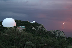
What you can't see from the images is where I was when taking them... I was actually on the 4-meter exterior catwalk located outside the big dome, about 100 feet off the ground. It was one of my favorite places on the mountain so far off the ground atop the highest mountain around. Unfortunately seven years later it became the location of a horrible accident where astronomer Marc Aaronson was killed and the exterior catwalk was closed off for all access. The image at right labels the telescopes located there at the time.


 The other IR plate exposure I had scanned is shown at left. There is a miniscule overlap, but they were taken from different vantage points so couldn't be combined... Here also, there have been some major changes in 35 years - the labeled version is at right. The Burrell Schmidt, one of the most beautiful restored telescope, is just right of center and had been installed just as I started work in 1979. So when this image was taken, it was less than a year old. Originally built and installed in Cleveland, OH (!) in 1939, it was moved to a countryside location in the 50s before its move to Kitt Peak in 1979. During its move, KPNO photographic scientist Bill Schoening, an expert in auto restoration, totally stripped, repainted and re-chromed the telescope. It is still there, but converted to CCD detectors, and NOAO has given up its interest in the telescope (operated by Case Western Reserve). When I arrived the dome adjacent to it at right housed a 12" Schmidt that was unused. I cleaned and used it for a while before it was given away to another institution. Another instrument used the structure for a while, which needed full-sky access, so the dome was removed and a roll-off roof was installed. When the visitor center started their public programs, they installed a 16" telescope for use. To that dome's right, the airglow dome was removed ages ago and is now a storage shed. Looking at the newer image above, the SARA telescope is just beyond this building and houses the parts left over from the reconstructed 36" as explained above. That is a long-winded explanation of most of the changes I've seen since these images were taken...
 Since these images are off 8X10 plates, there is a LOT of information on them. Cheapskate me, I didn't spring for the expensive hi-resolution scan ($25 each for these seemed high enough for me!), but there is much to be seen in close examination. Admittedly I wasn't paying attention to what was going on nearly a km away from where I was standing with the camera. But the camera captured a visitor who stood stock still for the 10 second exposure reading the signage on the 4-meter concrete mirror dummy. Also interesting is that perhaps his spouse was walking towards him from the restrooms at right - you can see the ghostly image of their feet where they were stationary for fractions of a second during the long exposure. And a little higher, you can see the US and what I think is the Tohono Nation flag on the pole near the kitchen, with the 1.3 meter dome at right. The flags are blurred from the long exposure, but also, the IR wavelengths tend to wash out even strongly colored inks and dyes. It is still interesting to me how well the individual bushes stand out on the distant ridgeline in the background at least 6 or 8 miles away! These images are shown at the full-resolution of the less-expensive scans...
Anyway, that is it for my ancient history lesson on Kitt Peak from long ago. It seems interesting that these images, which take up considerable space, are not easy to lose track of. With digital images, will it be as easy to keep track and pull up an image 35 years down the road? Given how hard it is to read a 3.5 inch floppy from 10 years ago, it remains to be seen!


No comments:
Post a Comment